Free camping in Hells Canyon
No road crosses the canyon. Choose your side before you choose a campsite.
Published November 2026
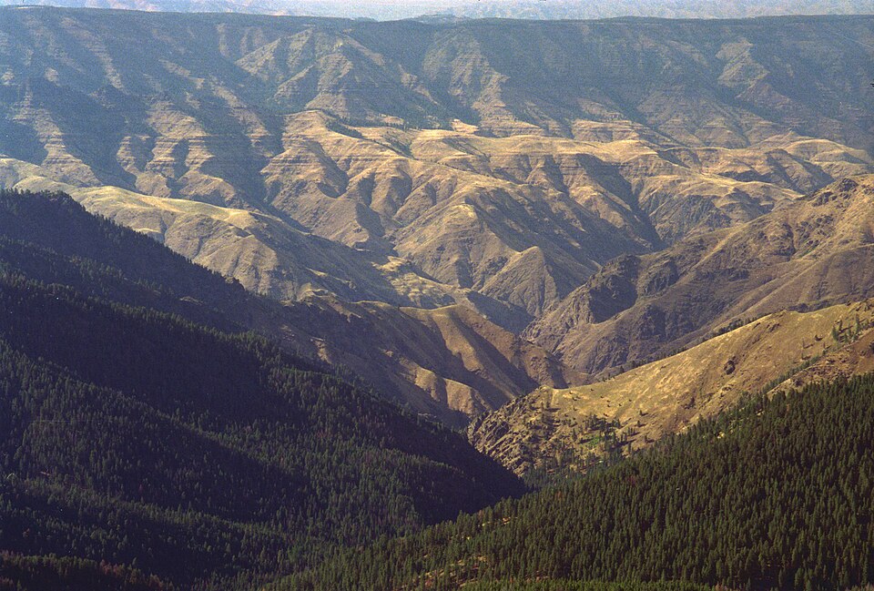
You’re planning two nights in Hells Canyon. The first is at Hat Point, in Oregon. A fire lookout stands there on the rim, and the river runs more than 5,000 feet below. You can camp there for free.
For the second night you’d like to sleep down by the water. On the map you find Big Bar, a free campsite on the Idaho bank among old fruit trees. It looks close. It’s 22 miles away as the crow flies.
By road it’s 99 miles, and about five hours. There’s no bridge in between. For about 100 miles below Hells Canyon Dam, nothing crosses the Snake River until Lewiston.
Hells Canyon is the deepest river gorge in North America. From He Devil Peak in Idaho down to the water, it drops nearly 8,000 feet. Roads come at it from three towns, and each one shows you a different canyon.
1. Pick your side of the canyon
Joseph, Oregon is the way to the high viewpoints. Hat Point and the Buckhorn Overlook both look straight down into the canyon from the west rim. Imnaha, at the bottom of the Hat Point road, has a small store that’s open all year.
Halfway, Oregon is the way down to the water. From Oxbow, a paved road runs about 22 miles along the Idaho bank to Hells Canyon Dam. It crosses on top of the dam and ends at a visitor center a mile further on. It’s the only paved road to the river inside the canyon.
Riggins, Idaho is the way to the Seven Devils, the peaks on the Idaho side. A gravel road climbs to Heavens Gate, where you look down on the canyon from the east.
Joseph and Halfway are about two hours apart in summer. Halfway to Riggins takes about three and a half hours. Joseph to Riggins is close to five. Pick one side, and camp on it.
2. Check the road is open
Forest Road 39 links Joseph and Halfway. It’s paved, and it passes the Hells Canyon Overlook on the way. Snow usually shuts it from late October until late May or June. When it’s shut, the two towns are a long way apart.
The Hat Point road climbs 23 miles from Imnaha. It’s one lane of gravel, and the first six miles are very steep. It’s usually open from June to October. A big RV will struggle to turn around on it.
The road to Heavens Gate is about 17 miles of steep, narrow gravel from the highway south of Riggins. It isn’t meant for RVs or trailers. Snow keeps it shut until about July, and it closes again in October or November.
The road to Buckhorn crosses the Zumwalt Prairie for about 40 miles from Joseph. It starts paved and turns to gravel. Nobody keeps it up out of season. If you’re towing, read how to check a dirt road first.
3. Bring your water, and fill up the tank
None of the campsites below has drinking water. Bring all you’ll need, plus some spare.
Fill the tank in town. There’s a store near Oxbow that sells gas and diesel, and Riggins has fuel stations.
Many of these places have a vault toilet. That’s a toilet over a pit, with no water. Some have nothing at all. Carry out your trash, food scraps too.
4. Plan for heat at the river and cold on the rim
Big Bar is about 1,700 feet up. In summer the canyon floor gets very hot. Rattlesnakes, ticks and poison ivy all live down there. Watch where you put your hands and feet.
The rim campsites sit between 5,200 and 6,900 feet. That’s about a mile higher than the river, and the nights are far colder. Pack something warm, even in August.
5. Carry $5 if you drive up to Heavens Gate
None of the campsites below charges you to camp or to park. A few trailheads nearby do. Heavens Gate and Windy Saddle, on the road up to the Seven Devils, charge $5 a day per vehicle. So does Freezeout, on the Oregon side.
A Northwest Forest Pass covers all three. It costs $30 a year. An America the Beautiful pass works too. Fees can change, so look for a sign when you park, and keep a few dollars in the car.
6. Leave the site the way you found it
- On the Oregon side and in the whole recreation area, you can stay up to 14 days in any 30. On the Idaho side away from the canyon, check the forest’s own limit.
- Many of these campsites sit at the edge of a wilderness. Past the trailhead, no motors and no bikes. The Eagle Cap Wilderness also asks for a free permit, one per group.
- Use a fire ring where there is one, and only when the rules allow it.
- In the fall, hunters use most of these places. Wear something bright if you walk in the woods.
Free campsites in this guide around Hells Canyon
Distances are by road from each town. Times on gravel are rough guesses. On each side, the campsites on the canyon come first.
From Joseph, Oregon
- Buckhorn: 41 miles, about 1 hr 35 min. A small campground in the trees, half a mile from the Buckhorn Overlook. Vault toilet.
- Hat Point: 52 miles, about 3 hr 20 min. On the rim by the fire lookout, with the river more than 5,000 feet below. The last 23 miles are one lane of steep gravel.
- Lick Creek (in the mountains): 26 miles, about 1 hr 5 min. A small trailhead into the Eagle Cap Wilderness, off Forest Road 39. No toilet.
- Tenderfoot (in the mountains): 24 miles, about 1 hr 35 min. A big trailhead in open pine, with room for trucks and trailers.
From Halfway, Oregon
- Big Bar: 31 miles, about 1 hr 5 min. Beside the river on the Idaho bank, among the fruit trees of an old ranch. One outhouse.
- Buck Creek: 42 miles, about 1 hr 35 min. A horse camp and trailhead on the ridge above the canyon. Vault toilet.
- PO Saddle: 45 miles, about 1 hr 50 min. A horse camp with a big view of the canyon, past the Hells Canyon Overlook. Vault toilet.
- Clear Creek (in the mountains): 11 miles, about 1 hr. A small trailhead in the Wallowas. The last mile and a half suits a high-clearance vehicle.
- Sugarloaf (in the mountains): 24 miles, about 1 hr. A large trailhead in open pine beside Forest Road 66.
From Riggins, Idaho
- Cold Springs: 18 miles, about 1 hr 5 min. A ridge-top trailhead on the north edge of the Hells Canyon Wilderness. Room for two or three vehicles.
- Iron Phone Junction (in the mountains): 15 miles, about 55 minutes. Four sites with fire rings and hitching rails, up Race Creek Road. Vault toilet.
- North Fork Slate Creek (in the mountains): 29 miles, about 1 hr. Five sites with tables where two creeks meet, on the Salmon River side. Vault toilet.
- Smokey Boulder (in the mountains): 31 miles, about 1 hr. Spots scattered along a forest road north of New Meadows. Busy with hunters in the fall.
Important: roads, fire rules and closures around Hells Canyon change every season. Before you go, check the Wallowa-Whitman National Forest’s alerts.
Find somewhere to camp
434 places to camp on public land across Idaho, Oregon, Utah, Arizona and Montana.